 |
 |
 |
||||||||||
|
Puget Sound Washington USA
|
||||||||||||
 |
 |
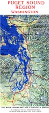
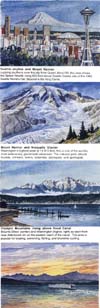
PUGET SOUND REGION, WASHINGTON, the Mountain/Inland Sea Evergreen Empire: Published in 1987 and considerably revised in 1993, the 24" x 37" map covers an area of over 70,000 square miles, extending from Chehalis in Lewis County on the south to beyond Vancouver, British Columbia, on the north, and into the Cascade Range and Olympic Mountains on east and west. The map margin features watercolors of scenic highlights of the region. The backside of the revised edition (1992) includes a reduced version of the map that shows (in varied colors) various governmental jurisdictions (incorporated towns, Indian and military reservations, national parks and recreation areas, national forests and wilderness areas). A chart lists all the state parks in the region, with information on their facilities and activities, and an extensive text summarizes the area's geography, climate, natural resources, culture and economy, history, national parks, and the region's geologic and glacial history—the structural development of the Olympic Mountains, Cascade Range, and intervening Puget liough, and the subsequent formation of the Cascade volcanoes. Also noted are some of man's impacts on the geologic processes. The map is a useful educational tool for classrooms and an attractive art poster for the office wall, and a handy travel reference for the motorist and cyclist. | ||||||||||
 |
||||||||||||
 |
||||||||||||
 |
||||||||||||